By Marc Fried
T
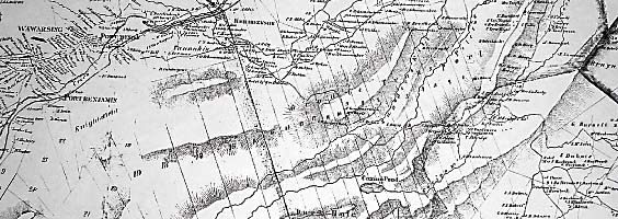
here's the Wallkill Valley on the southeast side, and the Rondout Valley on the northwest side (technically, the Neversink-Basher Kill-Homowack-Sandburg-Rondout Valley, but we won't go there). The Shawangunk ridge separates them, but also unites them, for the mountain is a presence common to the lives of people of both valleys. The two watercourses converge at the north end of the ridge.
The Esopus Indians had settlements on both sides of the mountain. For the Euro-American settlers of the late 17th and early 18th centuries, migrating inland from the mouth of the Rondout at Kingston, the confluence of the Wallkill and Rondout just below Rosendale was a fork in the road. French speaking Huguenots or (more precisely) Walloons, as well as members of the Bruyn, van Camp, Decker, Terwilliger, Jansen, Schut, Ten Hout, and Smedes families were among those taking the left branch to settle New Paltz and Shawangunk. Jacob Rutsen and members of the Vernooy, Schoonmaker, Cole, Rosakrans, and Van Gorden families were among those taking the right fork to settle Mombaccus (Rochester) and Wawarsing. But some crossed from one valley to the other, and settlers on both sides periodically returned northeastward, downstream toward the Hudson. This was really a journey back in time to their ancestral roots in Kingston and Hurley. They returned to visit friends and relatives who had stayed in those older settlements, they returned to exchange their wheat or other products of home and farm for the staples and manufactured goods they couldn't produce at home, and they returned to have their children baptized at the ancient Reformed Dutch church in Kingston, until such time as the inland settlements had grown large enough to support their own churches and ministers.
Though the Shawangunk ridge is a common presence for people of both valleys, it presents itself in two very different ways. The following paragraph is taken from my second book, Tales from the Shawangunk Mountains (no longer in print):
When seen from Ellenville or Napanoch, in the Rondout Valley, Shawangunk Mountain has an entirely different personality than when observed from the valleys of the Shawangunk Kill and Wallkill to the southeast. The houses and rambling farms of the southeastern valleys encroach freely on the lower reaches of Shawangunk's gentle slope, whose overgrown orchards and crumbling stone fences give way only gradually to a steep mountainside and, finally, a bold precipice. Here the mountain is an open book, for its concave features bask in full sunlight. It reigns over the broad, spacious valleys like a kind and benevolent monarch, wearing its lofty crags or winter snows like crown jewels. The northwest slope has its jewels too, but one must search in mysterious, shadowy places in order to find them: the mountain here is a dark and hulking presence that broods ominously over the thin strip of crowded bottomland at its base. From this narrow corridor it rears up with startling suddenness, climbs far into the sky, then disappears as it curves away to the southeast, guarding its upper reaches jealously from view. Where human habitations end, the steep mountain wilderness abruptly begins, like some mediaeval town wall separating burg from barbarous hinterland.
Though strict geographical determinism is a gross oversimplification of history, there are indeed ways in which this difference has colored life in the two valleys. From the southeast, the Shawangunk Mountain range is predominantly a visual and inspirational influence, and the ridge from Otisville to Rosendale is easily recognized as a single geographical entity. From the northwestern valley, the mountain's role has been more as an economic influence. Here the convex slope, and the lateral convex curve in the ridge line between Napanoch and Kerhonkson, both conspire to hide much of the ridge from view, from any single vantage point along the narrow valley corridor. But this same proximity that precludes
perspective has granted a
familiarity not easily experienced by those in the Wallkill Valley. Thus, millstone quarrying, berry picking, timber harvest, shingle and charcoal making and barrel hoop cutting, plus hunting during the era when most wild game had disappeared from the valleys, and employment at the Mohonk and Minnewaska Mountain Houses, were all readily available for those living in the Rondout Valley, for whom Shawangunk Mountain was literally their back yard.
When I was visiting and interviewing former berrypickers during the 1970s and '80s, it suddenly dawned on me at one point that, in conversation, few of the Rondout Valley folks referenced the Shawangunk Mountains by name. It was more commonly simply "The Mountain," or even "the huckleberry mountains," or people would refer to the Two-Mile Post or the Four-Mile Post or Mary Crose's or Sam's Point (all berry picking encampments), but rarely to the mountain range as a single geographical unit. This is not something I've ever encountered from a Wallkill Valley native.
Among more formally educated, prosperous and mobile folks, these differences have largely melted away since the advent of the automobile. But the cultural phenomenon I refer to clearly harks back to what was undoubtedly a much more common distinction 100 years ago than in more recent decades.
Today, it is easy to enjoy both the dark mysteries and lore of the Rondout Valley and the more panoramic aesthetic of the Wallkill. As never before, the Shawangunk range can unite rather than divide the people of its two equal and ultimately conjoined valleys.
[ Rate Card ] [ Advertisers ] [ Contributors ] [ info@gunkguide.com ] [ home ]